
Civil War II – An After Action Report!

In this multi-part AAR of Ageod’s Civil War II (“CWII”), I will be playing as the Union. I have very little experience in this game, so I will doubtlessly make a lot of mistakes along the way. I’ve set up the game with the following options:
Tripoli,

- Fog of War: ON
- Delayed Commitment: ON (Units in battles delay becoming engaged, depending on the skill of the commander)
- Foreign Entry: NORMAL
- Historical Attrition: ON
- Activation Rule: VETERAN (All leaders appear to be active until turn processing, then roll is made based on the skill of the commander. If commander fails, the unit will not move or may suffer significant combat penalties)
- Randomized Generals: ON/STRONG (Leaders have their capabilities strongly randomized from their historical performance)
- Reinforcement Pool: HISTORICAL
- Easy Supply: OFF
- Traffic Penalty: Medium (Too many units cause traffic slowdowns)
- AI Ranking: Lieutenant (slight detection/stack bonuses. No combat bonus)
- AI Activation Bonus: NORMAL (+1 on leadership activation)
- AI Detection Bonus: LOW (Slight detection advantage)
- AI Aggressiveness: NORMAL
In my opinion, CWII may be the most detailed strategic/operational level game on the US Civil War. Because of the level of detail, CWII provides a useful vehicle for discussion about strategy of the war. As I play the game, I will try to provide a commentary on my strategy, as well as the historical Union strategy. Comments in the Grogheads forum are welcome.
Before starting gameplay, I need to come up with a Union strategy, which in turn requires an analysis of the battlespace:
Analysis of the Battlespace
Significant Characteristics of the Battlespace Environment: The Area of Operations is geographically huge-the entire 3.119 million square miles of the continental United States. Confederate territory alone is almost one million miles in area.
This area is roughly divided in four theaters, which are partially geographically isolated from each other. These theaters are the Eastern, the Western, the trans-Mississippi, and the Far West. The Eastern Theater consists of the States of West Virginia, Virginia, Maryland and parts of Pennsylvania. It is largely separated from the Western Theater by the Appalachian Mountains which act as a barrier to large scale military operations. Only a rail line running between Baltimore to Harper’s Ferry and on to Ohio and a second line running through northern Pennsylvania allow for significant military movement between the Eastern and Western theaters. The CSA territory in this theater can only be entered from the north, through Virginia, or the south, via a march around the bottom of the Appalachians.[1]
[1] https://erenow.net/ww/theamericancivilwar/6.php

The theaters of the Civil War
Geographically, The Eastern Theater is the smallest area, amounting to only 118,280 square miles (if all of Pennsylvania is included). However, it contains some of the densest concentrations of population and industry for the CSA. It has the highest density of railroads, ports and roadways. It also features the capitals of both the Union and Confederacy. The Eastern Theater has a narrow and very defensible border between the USA and CSA. Here, the front is merely 125 miles long along the Chesapeake-Washington DC-Shenandoah axis, widening to 167 miles along the Chesapeake-Richmond-Shenandoah axis. Further, the rivers in this area run generally in an east-west direction, perpendicular to the north-south axis of attack. This gives the defender a series of defensive positions from attacks from the north or south. However, the defensive advantage of the Eastern Theater is partially mitigated by the long coast lines, which gives the superior Union navy the ability to extend or flank the Confederate defenses through amphibious operations. Additionally, the presence of a relatively dense railroad network and numerous seaports eases the problems of supplying a Union army in this theater.

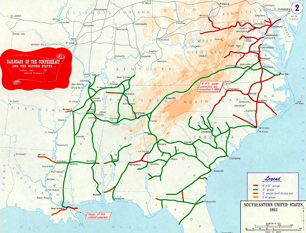
Railroad and ports of Confederacy 1861. Note: I’ve modified this image to include the Strategic Cities (denoted by stars) and the CWII port sizes (denoted by numbers indicating the size of the major and surrounding ports as denoted in the game)
The next theater is the Western Theater. It is largely separated from the Eastern Theater by the Appalachian Mountains and separated from the trans-Mississippi Theater by the Mississippi River. It is much larger than the Eastern Theater, with a total area of 315,364 square miles. The road and rail network in this theater is relatively under-developed. This, in addition to its size, makes movement and supply of large military units difficult and restrict most large military formations to operations along these rivers or the few rail lines that region.
Although the theater is difficult to traverse, the Mississippi and Ohio rivers offer excellent transportation routes along the northern and western borders of the theater. Additionally, unlike the Eastern Theater, the rivers in the west run in a generally north-south direction, allowing them to act as avenues of advance, rather than obstacles. Rivers such as the Tennessee and Cumberland Rivers offer a LOC into the south eastern portion of the Confederacy, effectively acting as a springboard for armies swinging around the southern Appalachian Mountains. Additionally, the long coastline opens up the possibility of significant Union amphibious flanking operations.
The third theater is the trans-Mississippi. It is geographically very large amounting to 576,955 square miles (if the entirety of Kansas, Texas and Louisiana is included) and largely undeveloped, having few significant population centers, ports, rail lines, roads and navigable rivers. This underdeveloped transportation system will limit the size of forces in this region. However, the lack of almost any militarily important objectives will limit the need for such large military formations. Only to the extent the region impacts transportation along the Mississippi River does the region become militarily significant.
The Far Western theater lies west of the 100 degree latitude and is generally separated from the trans-Mississippi by both its large size, undeveloped transportation network and the Rocky Mountains. It consists of the territories of New Mexico, Colorado, parts of Texas, the Dakotas westward to the Pacific Ocean. There are no military objectives in this region.
Overall, the South lacks large cities, and most that it has are deep within its territory or otherwise difficult to seize. Only Richmond lies within easy reach. (see Image 3. See also Image 2, showing the location of the Strategic Cities).

Urbanization of population, c. 1860
The absence of large centers of population and industry mean that the CSA can trade space for time, and require the Union to either make long, attrition-producing marches or travel along rivers. It also creates logistical difficulties in traveling over such long distances.[1], [2]
Political Geography
At the start of the game, South Carolina, Mississippi, Florida, Alabama, Georgia and Louisiana and Texas have seceded. In the game Virginia, North Carolina, Tennessee and Arkansas will also seceded according to the historical timeline. Presumably, the Arizona territory will also secede, as it did in 1862. The border state of Kentucky is neutral, and cannot be entered at game start. However, the border states of Missouri and West Virginia can be entered.
CWII tracks to public support for the union on a regional basis. The screen shot uses darker areas of blue to show higher levels of support for the Union, and darker areas of grey to denote support for the Confederacy. Notably, most of Missouri is grey, indicating strong support for the CSA in that state. The western shore of the Chesapeake, including Washington DC and Baltimore, also display pro-confederacy sympathy. Conversely West Virginia is decidedly pro-Union, and sections of east Tennessee and section of the Tennessee River extending into northern Alabama have pro-Union sympathy (Image 4).
[1] https://erenow.net/ww/theamericancivilwar/6.php
[2] https://eh.net/encyclopedia/the-economics-of-the-civil-war/

Political loyalty by region. (Darker Color of Blue=Pro-Union; Darker Color of Grey=Pro-CSA)
The CSA has a higher national morale (100) than the Union (85). Moreover, the CSA morale must be reduced to 20 to trigger an auto victory, as opposed to the Union, which must be reduced to only 40.
At the game start, the foreign intervention score is only 2, meaning that at the start of the game, the CSA will have a difficult time in convincing European powers to assist them.
Economic, transportation, manpower and population
The Union has a decided advantage over the Confederacy in terms of manufacturing capability. In 1860, the value of manufactured goods in the North was 11 times that of the south.[1] In CWII the CSA has half the rail capacity and 67% of the riverine transportation capacity. The Union has approximately 3.5 times more male military age population than the Confederacy. [2]
Summary:
In summary, the Confederacy enjoys more political support, allowing it to suffer more defeats before losing the war than the Union. It is geographically large, with a dispersed population and industry, allowing it to trade space for time. In contrast, the Union has a much larger economy and pool of manpower, allowing it to build a larger military. Its naval advantage will allow it to open up the entirety of the confederate coastline to attack, as well as allowing the Union to by-pass or flank Confederate defensive positions.
Strategy
The Union wins if it gets to 200 national morale points, or if it gets more victory points for taking cities and objectives. The Union will lose if it falls below 40 national morale points. The Union begins with a national morale of 85, so I can only lose 45 points. Morale is lost or gained by winning and losing battles and taking objectives. Additionally, war weariness can affect national morale. Because of these factors, the Union’s first objective is to avoid losing battles, and quickly winning the war. By simply not losing, the Union should be able to get more victory points by game’s end.
Based on this analysis, I will be following a modified Anaconda Strategy, similar to that proposed by General Scott in June 1861. The Anaconda plan called for a full blockade of the Southern coastline and control of the Mississippi River, isolating Texas, Arkansas and Louisiana from the CSA. The resulting economic strangulation would then break the morale of the secessionist faction. The problem with the Anaconda plan is that war weariness in the north and southern intransigence will likely result in a political defeat. Unlike the more passive Anaconda strategy, my strategy will also employ a “roll back” element to capture territory after the blockade becomes effective. By doing this, I hope to trigger an auto victory before war weariness begins to cut into my national morale.
Like Scott, I will seek to initially blockade southern commerce. Because of the weakness of the Union fleet, initially this blockade will have to be a distant blockade in the Atlantic and Gulf of Mexico, while the Union Fleet is built up. This blockade will probably intercept no more than 15-20% of CSA commerce. As the navy is built up, I will establish close blockades (in order) of the Chesapeake Bay, New Orleans, Charleston, Savannah, Wilmington/Outer Banks, and Mobile. This will necessitate building a blue water fleet approximately 4-5 times larger than my starting navy. Additionally, a brown water riverine fleet will need to be built up for use on the Mississippi. Because of the time it takes to build this fleet funding the navy will be a priority for the first few months of the war.
I will try to avoid a major attack in the eastern theater in 1861. This is primarily because the Union needs to build up its army and navy and the necessity to avoid loss of political capital from any defeat. Additionally, delay means that the Union troops can be better trained and organized to maximize the chance of military victory. In CWII, the Union is unable to form divisions until October 1861, and cannot create Corps until early 1862. These formations provide combat bonuses that will help minimize some of the southern military advantages. As this larger and better organized force cannot be fielded until early 1862, large scale offensive operations will be delayed until then. While waiting for this larger force to be built, I will fortify Washington, DC to prevent its capture along with the devastating political consequences such an event would bring.
While I will engage in no major offensives in the East, I will try to secure the B&O rail line from Baltimore to Ohio along the Harper’s Ferry/Clarksburg/Marietta line to open up this LOC between the Eastern and Western Theaters. I will also try to seize Manassas to cut the rail line to the Shenandoah, and use this position as a starting point for a future push to Richmond. Additionally, I may stage some amphibious operations to seize bases for blockade purposes along the Atlantic and Gulf coast.
In the West, I will first focus on building up an invasion army to seize Kentucky after it ceases to be neutral. From there, I will move into Tennessee sometime in the fall, although the exact axis of advance is undetermined. I am guessing that the Confederate armies in this region will be relatively small, so a number of small division-sized Union forces should be able to seize key terrain without too much fighting. Finally, I will secure West Virginia along its border with the Ohio River to open up the river to traffic along its entire length.
In the trans-Mississippi, I will try to force the Confederates out of Missouri by December 1861. This will open up the Ohio and Mississippi Rivers down to at least Cape Girardeau, and possibly Memphis, freeing up the Union occupation forces for the 1862 offensive in the Western Theater.
My goals in 1862 will be to complete securing the Mississippi River along its entire length, as well as complete the blockade of all the major southern ports, and the seizure of both Richmond and Atlanta. This will effectively divide the CSA into three sections. 1863 will be devoted to destroying the confederate armies in detail, hopefully accomplishing this task before war weariness sets in. See Image 5.
[1] http://gorhistory.com/hist110/unit4/CivilWar.html
[2] https://www.nps.gov/articles/industry-and-economy-during-the-civil-war.htm

General plan and axis of advance. 1861-62
Finally, to the extent possible, I will try to engage in simultaneous military operations. The purpose of this is to tie down as many Confederate forces as possible, ensuring that the CSA will be unable to shift forces to any single threatened region, without risking the loss of other regions. This will be difficult, because I will not know which of my generals fail their activation checks until after the turn begins to execute.
Check back for Part 2!
Sources:
Civil War: Goals, Strategies and Consequences. (n.d.). Retrieved from http://gorhistory.com/hist110/unit4/CivilWar.html
The Economics of the Civil War. (n.d.). Retrieved from https://eh.net/encyclopedia/the-economics-of-the-civil-war/
Industry and Economy during the Civil War (U.S. National Park Service). (2017, August 23). Retrieved from https://www.nps.gov/articles/industry-and-economy-during-the-civil-war.htm
Railroads of the Confederacy. Retrieved from https://upload.wikimedia.org/wikipedia/commons/f/ff/Railroads_of_the_Confederacy_%26_the_Border_States.png
The Military Geography of the Civil War. (n.d.). Retrieved from https://erenow.net/ww/theamericancivilwar/6.php
Chat about it below, or in our forums, or hit our FaceBook page >>
